ul class="overview_list " id="projectList">
  • Schönefeld Nord

    How can a missing piece in the urban puzzle holistically bring together airport, landscape and existing neighborhoods?

    At the border between the capital, the airport and the countryside, Schönefeld's „quarters of landscapes" combines the qualities of a major city with those of the surrounding countryside.The new urban component strengthens the qualities of Schönefeld and qualifies the existing landscape spaces. In the process, a rich urban ecosystem with great biological diversity is created.

    The northern landscape is strengthened and open space qualities are recognized for new residential locations. The starting point is the northern landscape band consisting of the Brandenburg field landscape in the west, the former Wall strip, the Rudow South Park and the Rudow-Altglienicke Landscape Park in the east. A mixed neighborhood forms the southern edge. Here, in the immediate vicinity of the train station, a compact, urban neighborhood with a strong mix of uses is being created.

    Diverse new urban quarters are located in the heart of characteristic open spaces. They create living space for a total of 11,500 new residents of Schoenefeld and 4,000 jobs in the immediate surround-ings of the train station and airport. They are characterized by their direct access to nature, short dis-tances and vibrant urban centers. A wide typological variety and a broad spectrum of public, neighborhood and private open spaces create the foundation for a variety of different forms of housing and lifestyles.

    Idea
    2022
    Schönefeld
    Germany
  • Bochum Gerthe-West

    Three neighbourhoods for a green network.

    The focus of the spatial image for the inner-city development Bochum Gerthe-West is the connection and interweaving of the existing green spaces. As a starting point for the design, they create a new ecological corridor and open space network. Furthermore, the connections between existing centralities and free spaces are strengthened and supplemented with new sources of inspiration, such as new daycare centres and mobility hubs. Strategically placed, they form bridges between the building structures and natural areas and invite you into the green.

    The design suggests a coherent and lively green sweep that can be experienced and used by residents and residents through small-scale path connections and other open space functions.

    The rich stock of shrubs and trees creates distinctive rooms and atmospheres. Building structures are specifically inserted here. This creates a compact residential area in the northern part that fits into the built urban context. The focus here is on diverse neighbourhood-related open spaces that offer room for communal uses. In the northeast, the green urban landscape is supplemented by four rows of block edge and row house typologies. They define clear settlement edges between the residential area and the landscape and still have strong visual references to the vastness of the adjacent fields. The Green Ring runs between the neighbourhoods, taking up the striking trees and networking the area for non-motorized traffic.

    New typologies are set along with the dense forest structure in the heart of the project area. In the so-called wilderness quarter, residents can experience nature. Open, small-grained and carefree play with the trees, the new buildings create an urban wilderness.

    Key figures
    Area of ​​new development: 19,302 m² (21,769 m² *)
    Gross floor area new development: 60,771m² (68,173m² *)
    Sealed areas total: 59,286 m²
    Total unsealed areas: 63,980 m²
    Approximate number of residential units: 560 (625 *)
    Number of parking spaces in district garages: 557 (668m² *)
    *including optional surfaces

    completed
    2021
    Bochum
    Germany
  • Marconiplein

    How to raise a dike in an innercity environment?

    Nexus, from the Latin 'nectere', means a "connection or series of connections linking two or more things". Marconiplein is, indeed, at the crossroad of different flows: not only mobility but ecology, water protection, development.

    Our vision is rooted in the understanding of this space as a complex node, where traditionally, absolute priority has been given to transport. Our proposal aims to invert the paradigm of Marconiplein as a space - a sum of several leftover spaces- defined by infrastructures, but rather, addressing high-quality public spaces first, where infrastructural strategy follows. The design of the new square will be led by the principle of unveiling. If in history, infrastructures - considered as a major source of disruption - have been buried, hidden and elevated, technological progress and accurate urban solutions, offer now the opportunity of reconnecting to infrastructures.

    Specific solutions will range from sloping squares, new vertical cross-views, increased number of entrances, fostering the square as a seamless public space, where infrastructure is no more perceived as separated from the city.

    completed
    2021
    Rotterdam
    The Netherlands
  • Tannenberg Quartier

    The Tannenberg quarter is characterised by a distinct build framework that forms a clear centre and protects the quarter from traffic noise. An independent ensemble.

    The entrances and views of the quarter integrate into the existing context. The network of paths creates several links to the allotment gardens and the neighbourhood to the west: The Gumbinnenweg with its prominent row of trees becomes the main link for pedestrian and bicycle traffic. Private gardens and surrounding garden paths form connecting transitions to the private gardens of the neighbouring residential buildings and the allotment gardens (Klönschnack am Zaun).

    The generous open spaces with dense tree population ("grove") and the various garden areas have a significant influence on the character of the quarter: this is where you live "garden green".

    Idea
    2020
    Bremen
  • Mühlenleine

    A river in the middle of Hannover's city center holds the potential to be an inviting, green place where city dwellers enjoy spending time. Currently, valuable areas along the Leine's shores between the river and the Cityring are neglected and underused.

    In pre-industrial times, the Leine and its tributaries were among the river systems in northern Germany which had the highest quantity of salmon. During industrialization and the resulting pollution of the water bodies many fish species have disappeared. The reduction of the fish stock is linked for example due to the construction of hydroelectric power plants and dams, and the large-scale river development carried out in the 20th century.

    Numerous projects since the 1970s have restored and improved the water quality and the ecological connectivity. The renaturation of rivers is an important contribution to a resource-efficient and ecological city.

    In the confined spaces of a city, a particularly large number of different demands are placed on water bodies. However, numerous potentials along the Leine remain unused in the inner city. Further, the canalization and urbanization of the stream only allows to a limited extend the return of flora and fauna to the city. Renaturalised rivers in the city can help to cushion the effects of climatic changes. For example, riparian areas can be integrated into flood protection by retaining the water during periods of extreme rainfall. In addition, the design addresses urban planning goals, such as making the river shores more attractive and easily accessible for the citizens.

    Since the Leine is an urban river, it ought to be addressed both in ecological as well as in social terms. Various interventions along the riverbank serve to revitalize and enhance the quality of life. The key part of the project are the renaturation of shore opposite to the "Hohes Ufer", the reduction of the cityring and the fish ladder. In these areas, new habitats for flora and fauna are created along with new places and functions for recreation. The fish ladder close to the Friederiken Bridge, will enable the connectivity and improvement of existing habitats and it will increase the visibility of the Leine in the city as a unique selling point.

    The concept for the renaturation of the Leine was presented on the 29the of September 2022 with the Leinewelle e.V. and Angler Association and published in the Hannoversche Allgemeine Zeitung (HAZ), among others.

    Idea
    2022
    Hanover
    Germany
  • The multimodal City / Transformation Freeway B3

    Alternating the inner-city freeway B3 offers chances of enormous quality. In place of a disruptive gap with high infrastructural means, a continuously livable city can emerge along the freeway. A city that is balanced multimodally with all its functions, spaces and atmospheres. The integration of transit spaces as well as thinking built environment and free space together enables a programmatic diversity and synergies which can react to change. Besides the task of keeping up the traffic flow, barriers, noise and emissions are being reduced and inner-city plots are being reclaimed for urban developments.

    The chosen street section in the "Leinemasch" minimizes the intervention in the landscape. The Willmerstrasse is being transformed into a lively city street with high living and sojourning qualities by implementing a tunnel for the freeway, starting from Schützenstraße. East of the Hildesheimer Straße a Tunnelpark emerges with high qualities of open space for the adjacent urban areas. In addition to optimizing the freeway itself, sustainable mobility and transport are being valorized massively: Ricklingen in the west and Döhren in the east are connected with a bicycle highway and a tangential busline.

    completed
    2015
    30519 Hannover
    Deutschland
  • ecovillage Hanover

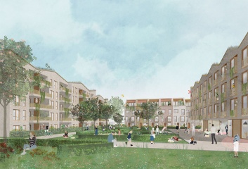
    With the development of the ecovillage in Hanover, there is a great chance to make an important contribution to future-oriented urban development. One of the most specific features of the ecovillage, and its guiding principle, is sufficiency. To possess more by sharing more: a highly flexible approach that, here, is not only preached but also practiced. In addition to a co-working space and several workshops, ecovillage also offers common rooms in the buildings and gardens that belong to and can be used by everyone, and there is even a special guest house for visitors to stay the night.

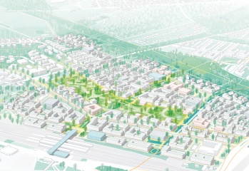
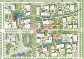
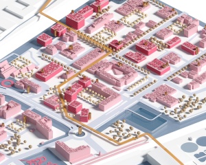
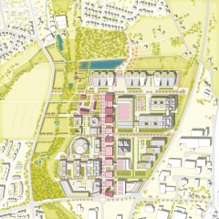
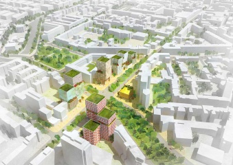
    The nucleus of the urban design is the lively village square, that is surrounded and framed by the commons. This is the green heart of ecovillage; where water is being managed, food is being produced and the spirit of community is being lived.

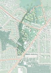
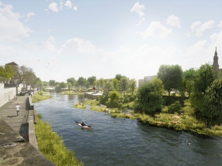
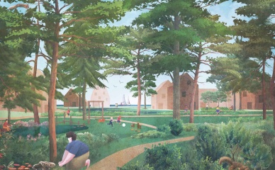
    One of the drivers for the development was the ambition to become a CO2-neutral settlement. Everything is built from wood, and the sealing of the surfaces is being minimized as well. Biodiversity is promoted and gray- and rainwater are treated and cleaned with the help of a plant-based sewage treatment system. After being directed into a biotope-like lake, it seeps away and evaporates, or serves the residents to water their gardens.

    The mobility concept also sets high goals with regard to future viability: it focuses entirely on local mobility. (local public transport, as well as pedestrian and bike path traffic). In concrete terms, this means only 0.2 parking spaces per residential unit are provided. In return, however, there are generous areas for bicycles, rental stations, handcarts, etc. A direct connection to the light rail system rounds off this concept.

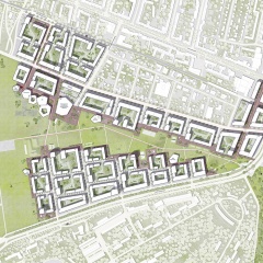
    The neighbourhoods, which are connected to each other and to the centre by the commons, consist of differently sized clusters. These clusters comprise various building typologies, which in turn provide space for a wide range of apartment forms. This 'democratic' housing mix promotes social integration and creates strong neighbourhoods.

    ecovillage can be regarded as a pioneer in a long-overdue discussion of principles in which frugality is pursued as a philosophy.

    All facts

    500 residential units
    900 inhabitants
    5 hectares total area
    2 hectares of garden land
    3100 m² of commercial space
    2500 m² communal facilities
    Start of construction in 2021
    Completion in 2026
    More information: ecovillage-hannover.de

    in progress
    2020
    30539 Hanover
    Germany
  • TXL Restart. Integral Systems

    The airport Berlin Tegel is going to be closed down. TXL will be developed as a high-quality research, industry and business park with the profile of 'urban technologies'. A strategic master plan builds the foundation for a flexible - and therefore, robust - planning process. Developmental guidelines and a profound system of rules create a structural, programmatic and creative quality of strategic important subareas.

    Simultaneously, more flexible developmental options are being allocated for other areas. ‚Quarters' profiles' emphasize existing potentials of subareas and strengthen the specific identity. An integrated concept for energy and water supports sustainable development: biomass, geothermal energy, wind energy and photovoltaics provide regionally generated energy. Gray and rainwater is being collected, refined and reused regionally. An urban aerial railway connects the site with the station and the tram. Here, the aerial railway is not only an efficient, sustainable means of transport but also represents sustainable mobility in terms of the site's profile.

    completed
    2012
    Saatwinkler Damm 62
    13627 Berlin Tegel
    Germany
  • Kenniseiland

    DARE TO INNOVATE!

    As a part of a workshop procedure, Cityförster, together with Openfabric Landscape Architecture and Mijn WaterFabriek Systemen voor duurzam water, proposed an integral strategy for the Business & Science Park of the Kennispark in Enschede that tackles not only the challenges of extreme weather conditions but also the energy transition towards a CO2-free built environment by 2050. The concept is based on the construction of a blue buffer around the location that creates more space for rainwater, recreation and reinforces the identity of the location. Together with a network of smart rain barrels and 'The Hub' arises an inclusive system that celebrates conscious water and energy consumption within a green-blue-minded environment.

    CHALLENGES AROUND WATER MANAGEMENT
    The capacity of our current sewerage system is not designed for extreme downpours. If there is an overload, in a mixed system, the untreated wastewater is dumped into the surface water together with rainwater. That is why it is better to retain the rainwater locally. By temporarily retaining rainwater locally, damage can be limited. The peak of the discharge of rainwater towards the sewer is shifted in this way: the rainwater only flows slowly towards the sewer pipe when it is empty again. Rainwater can be retained by constructing wadis, ditches, above-ground water buffers, green roofs, rainwater ponds, underground storage facilities, water squares, or rainwater use installations. Where soil conditions allow, the rainwater can also be infiltrated directly by softening and greening as much as possible. However, to limit damage during heavy cloudbursts, this must always be combined with other water-retaining facilities, especially in places where infiltration is not possible due to high groundwater levels.

    On average, we use almost 135 liters of drinking water per day. Most of the drinking water is used for showering, flushing the toilet, and washing machines. Drinking is really just a little bit. A family pays an average of almost € 750 for the water supply: 30% of this is for the supply of drinking water, 26% for the sewage charge, and 44% for the purification and water system charges. Instead of disposing of clean rainwater with the sewer, you can also store and use it. Rainwater that falls on roofs is relatively clean. You can use it for the washing machine or the toilet, but also to water the garden. This way, it does not immediately disappear into the sewage system and it also saves drinking water. Furthermore, the consumption of water could be reduced by raised awareness among the citizens and businesses. It is also important to improve the efficiency use by e.g. installing water-saving showers and toilets. Greywater treated in wetland or through filters could also be reused.

    You can find a link to a reader (Dutch) with all the results of the workshop here.

    completed
    7511 AH Enschede
    Niederlande
  • Cradle-to-Cradle Industrial Park

    The concept Cradle-to-Cradle (C2C, Michael Braungart et al.) is based upon the idea of a circular economy in which resources are not consumed but are continually used. The feasibility study explores how this concept can be transferred to the development of industrial parks: C2C-principles for the design of buildings, open spaces and infrastructure are developed and a structural plan for a test site in Bielefeld, Germany, is laid out.

    Moreover, an energy system for the whole area is designed and C2C-prototypes for buildings and open space situations. The approach of the study is holistic and interdisciplinary and its planning recommendations can be used for the development of new industrial areas as well as for the transformation of existing sites. The study is part of the INTERREG-IVB project „Cradle to Cradle Business Innovation & Improvement Zones. C2C-BIZZ". Please contact us for the entire feasibility study.

    completed
    2014
    Am Niedermeyers Feld
    33719 Bielefeld
    Germany
  • Holtenau-Ost

    New urban coastal landscapes

    With Holtenau-East, a new urban coastal landscape is being created on a former military site on the banks of the Kiel Fjord, which interweaves previously separate settlement structures and natural habitats. Holtenau East is defined by two impressive local scenes. On the one hand the Kiel Fjord with its maritime waterfront, on the other hand, the Endmoränen forest with its distinctive topography. They not only create the stage for the new development but are protagonists by representing the climatic, ecological and cultural context. The design further develops these two elements in terms of landscape and urban development and combines their spatial and atmospheric qualities to create a new urban coastal landscape. The result is three urban landscapes with a strong character.

    Together they form a closely networked and circular district landscape developed from the site. The three quarters provide strong, site-specific answers to future living, work and leisure needs. They differ in their use of water through adapted and integrated flood and sponge city concepts that strengthen the local ecosystems. Diverse structural and open space uses close to the water ensure a high quality of living. At the same time, they improve the range of jobs, supply, cultural and leisure offers for Holtenau and the surrounding communities.

    The rainwater is collected decentrally on green roofs and retention areas and feeds a central wetland, which reduces the rainwater load on the drainage system during peaks of precipitation. The wetland saves supply costs and complements the public space with atmospheric elements. It also offers a habitat for birds and butterflies, offers potential for nature-educational offers and protects the area from flooding.

    Idea
    2021
    Kiel-Holtenau
    Germany
  • Kurt-Schumacher-Quarter "Open Wild Tegel"

    The impressive wide heath landscape of Tegel forms the identity-creating heart of the new district. It is "wide, open, wild and free". This landscape is shaped by a vivid seam, that maximizes the contact surface to the landscape. Schools, kindergardens and public squares activate this space. Here one can play, learn, rest and socialize. A variety of building typologies characterizes the district and offers a great diversity of programs. Residential buildings increase towards the seam, while offices and retail are more likely to be found at the well accessible edges. In Tegel one can find bigger and smaller buildings with panoramic views or gardens, intimacy or openness.

    Idea
    2016
    Kurt-Schumacher-Damm 38
    13405 Berlin
    Deutschland
  • Framework plan federal district of Bonn

    In recent years, the Bundesviertel in Bonn has transformed into a successful business location and headquarters of the United Nations. Today, the district in the former federal capital faces new challenges to remain and become attractive as a location for companies, politics, international institutions and congresses and at the same time as a 'piece of the city'. The aim of the framework plan is therefore to show an integrated approach for future development.

    One of the main goals of the structural concept is to preserve and strengthen the identity-creating areas and to develop the inner potential areas structurally and openly in a sustainable manner. With the increase from currently around 4,000 to around 15,957 inhabitants, new needs arise in terms of supply and socio-cultural infrastructure.

    The Bundesviertel of the future is urban mixed, offers affordable and attractive living and working space, is characterized by social and cultural, sports, leisure and supply offers as well as high-quality open spaces. Through more and a variety of living spaces, commuters become residents. As a sustainable location, the Bundesviertel is changing from a simple office location to a work landscape ('work-life blending'). A crisis-proof and innovation-promoting mix of industries offer employees an attractive working environment.

    The concept is rounded off by a high-performance transport infrastructure that guarantees quick accessibility and good internal networking: An important role model for the traffic turnaround: cycle paths and footpaths are being greatly expanded and public transport is being strengthened.

    completed
    2022
    53113 Bonn
    Deutschland
  • Blankenburger Süden - Circular City

    The design is based on the concept of a "Circular City", a circular organised neighbourhood, and is guided by the spatial principle "Landschaf(f)tStadt": The landscape creates the city.

    A structural and design focus is on the blue-green infrastructure: a 60-hectare landscape park with garden, forest and water land not only offers various places for leisure, sport and recreation but also provides numerous ecosystem services such as climatisation in urban areas, rainwater management, food production and the strengthening of biodiversity.

    The neighbourhood is divided into four sub-sections, each with its own specific building and open space structure. All buildings open up to green space and offer a variety of affordable housing options. Construction with wood and recycled materials and the creation of blue-green roofs contribute to the neighbourhood's good climate balance. A new type of building, the so-called CYC Hub, acts as a circulation interface. It houses the technical infrastructure of the circular organised neighbourhoods - such as the energy station and the neighbourhood garage with a mobile station as well as socio-cultural and educational facilities such as a kindergarten, youth club, neighbourhood meeting place and neighbourhood management.

    completed
    Berlin
    Germany
  • Lively skyscraper ensemble

    The city of Berlin is characterized by solitary peaks that build up little connection to each other. The skyscraper confetti thus forms the opposite position to the clearly defined perimeter block development. The design area, as a gateway to the densely populated area of the City West, brings the great potential of four related properties and their simultaneous development.

    A cluster of 2-3 high points will be formed on each plot, inspired by the diverse buildings in the surrounding area. The distribution of the building mass on different high points makes the buildings resilient and efficient since they can be divided and used differently. The concept is based on the continuation of the diverse and sophisticated urban structure while at the same time ensuring high land utilization. By emphasizing the intersection as an urban, high-density hotspot, a new location with special centrality and distinct urban conciseness is created.

    Idea
    2018
    Berlin
    Deutschland